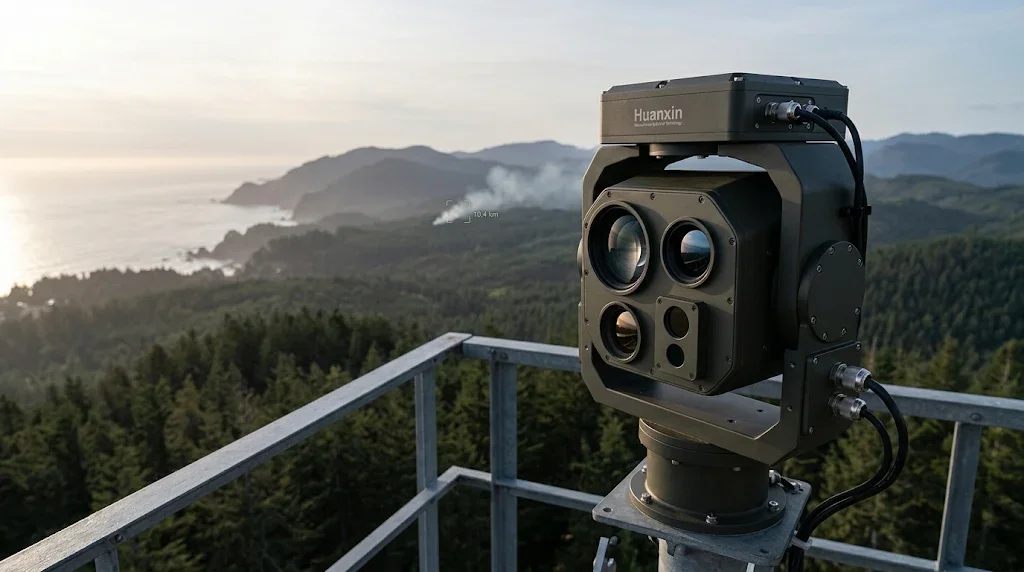
Long-range electro-optical systems deployed along rugged shorelines and remote ridge tops face a fundamental challenge: cameras see threats, but they cannot locate them. A high-resolution thermal camera on a mountaintop watchtower can detect a faint heat plume twenty kilometers away, but a flat video screen provides no depth perception. Is the smoke rising from a controlled burn five kilometers out, or is it an out-of-control crown fire raging twelve kilometers away on the opposite ridgeline?
Integrating a dedicated long-range surveillance LRF into your electro-optical and infrared (EO/IR) payload turns passive observation into actionable 3D target coordinates. When paired with digital compasses, precision pan-tilt encoders, and internal GPS units, the rangefinder bridges the gap between raw video streams and decisive operational response.
The Shift to 10km+ Ranging in Surveillance
Early border surveillance and fire lookout networks relied almost entirely on high-magnification visible zoom cameras and cooled mid-wave infrared (MWIR) imagers. While these sensors deliver clear visuals, visual feeds alone leave emergency teams guessing about precise coordinates.
Why Thermal and Visual Cameras Need Optical Depth
Camera zoom lenses compress perspective. Over open water or uniform forest canopies, human operators and automated tracking algorithms struggle to determine whether an object is small and close, or large and distant. A five-meter fishing skiff two kilometers offshore presents a similar optical profile to an eighty-meter patrol ship twelve kilometers out. Without an accurate range reading, video analytics cannot calculate a target's true speed, size, or travel vector.
Spatial Triangulation for Instant GIS Mapping
By firing an eye-safe nanosecond laser pulse at the target and timing its return echo, the laser module determines the target's distance down to the meter. The system combines this distance with the gimbal's azimuth and elevation angles, feeding exact geographic coordinates straight to dispatch networks. Water-drop aircraft, patrol craft, or tactical border units receive direct navigational coordinates within fractions of a second.
Canopy Watch: Laser Rangefinder for Forest Fire Observation Tower Platforms
Forest fire monitoring stations operate from exposed steel structures atop ridgelines, where they endure strong wind vibration, wide diurnal temperature swings, and severe heat shimmer.
Penetrating Heat Turbulence and Airborne Ash
Solar heating creates intense ground radiation, turning mountain valleys into turbulent thermal air currents. This optical scintillation breaks up ordinary, wide-divergence laser beams. Narrow-beam solid-state emitters (< 0.5 mrad) cut through these mirages without bleeding energy into surrounding air columns.
Furthermore, active forest fires create thick curtains of smoke and airborne soot. Early-generation rangefinders frequently trigger false alarms when light bounces off ash particles near the lens. Advanced 10km modules use multi-target discrimination and programmable range-gating logic:
Initial Gate Delay: Ignores any atmospheric backscatter within the first 500 to 1,000 meters.
Peak Detection: Analyzes the full waveform return to separate semi-transparent smoke from dense timber lines.
Last-Target Logic: Locks onto the solid ground return, returning the exact coordinate of the fire front.
Coastal Border Defense EO Sensor Integration
Marine boundaries present unique environmental hurdles: high humidity, salt spray, marine fog, and low-contrast surface targets. A successful coastal border defense EO sensor integration requires hardware built to handle moisture-laden environments and long line-of-sight absorption.
Detecting Stealth Vessels in Sea Clutter
Smugglers and rogue vessels frequently ride low in the trough of ocean waves to stay beneath conventional coastal radar sweeps. When high-magnification thermal cameras detect a heat plume or spray wake, the long-range surveillance LRF locks on with high-repetition bursts (1 Hz to 5 Hz continuous). Real-time distance tracking allows the turret to maintain target lock, calculate intercept trajectories, and illuminate targets with long-range searchlights or directional acoustic devices.
Wavelength Selection: 1535nm vs. Traditional Emitters
Older surveillance designs relied on 905nm semiconductor diodes or 1064nm Nd:YAG flashlamp lasers. Both present significant operational drawbacks: 905nm lacks the pulse energy required to push beyond three to five kilometers in wet air, while 1064nm poses extreme retinal hazards over open ranges. The modern standard for long-range surveillance payloads is the 1535nm erbium-glass (Er:Glass) laser.
10km 1535nm Rangefinder PTZ Camera Payload Advantages
Human eyes absorb 1535nm radiation in the cornea and lens before it reaches the retina, providing genuine Class 1 eye safety under standard operational parameters. This allows continuous perimeter scanning over populated public beaches, navigable shipping channels, and national parks without liability risks.
In addition, 1535nm falls into an atmospheric transmission dip where water vapor absorption is minimal, allowing high-energy pulses to travel through marine haze and light drizzle with lower attenuation than shorter wavelengths.
Precision Boresighting and Perimeter Security Optical Distance Measurement
A 10km rangefinder must maintain strict optical alignment with both the daytime zoom camera and the thermal imager. At a ten-kilometer distance, a minor 0.2-milliradian misalignment throws the laser spot two meters off-target, striking open water or empty sky instead of the intruder.
Thermal Drift Management
Surveillance gear installed on mountains or along coastlines can see daily surface temperature swings of over 40°C. Low-grade sensor brackets expand or contract unevenly, causing boresight drift. High-reliability OEM assemblies feature athermalized mechanical barrels and precision-machined aluminum-invar interfaces, preventing optical divergence across temperatures ranging from -40°C to +65°C.
OEM Integration with Huanxin Measurement & Control Technology
Off-the-shelf sensors rarely match the exact structural, weight, and electrical requirements of customized EO/IR gimbals. System integrators building specialized surveillance towers, coastal surveillance vehicles, or maritime patrol masts require targeted hardware flexibility.
Huanxin Measurement & Control Technology Co., Ltd. designs and manufactures specialized laser rangefinder modules built for integration into demanding platforms. Engineering support includes:
Custom Chassis & Optical Windows: Form factors designed to fit into narrow pan-tilt payloads, complete with anti-reflective and hydrophobic optical coatings.
Communication Protocols: Native support for standard industrial interfaces, including RS-422, RS-232, TTL, and CAN-bus protocols.
Firmware Adaptations: Configurable repetition rates, adjustable multi-target return prioritization, and specialized range-gating parameters to match your proprietary tracking algorithms.
Operational Frequently Asked Questions
How does a 1535nm LRF handle reflective ocean water?
Flat, calm water acts as an optical mirror, reflecting light pulses away from the receiver unless the beam hits perpendicular to the surface or catches the wake, hull, or breaking spray of a vessel. Modules designed for coastal integration feature wide-dynamic-range photodetectors that register faint returns scattered off vessel hulls and bow waves, ignoring calm surface dropouts.
Can thick smoke prevent the laser from reading true ground distance?
Dense smoke scatters a portion of the laser beam, but pulse-gated electronics filter out immediate backscatter reflections. By configuring the module to capture the "last echo," the receiver ignores the initial cloud reflections and registers the solid, non-transparent terrain behind the smoke front.
What power supply requirements are typical for 10km modules on solar-powered towers?
Modern solid-state 1535nm rangefinders draw very little power. They consume less than 1.5W in standby monitoring mode and briefly pull between 10W and 20W during active laser firing cycles. This low energy draw fits easily within off-grid solar-and-battery power budgets.
What is the practical lifespan of an erbium-glass laser module in continuous surveillance?
Solid-state Er:Glass modules regularly deliver tens of thousands to hundreds of thousands of shots without laser diode degradation. Routine maintenance involves cleaning exterior optical windows and checking mechanical boresight alignment after severe storms.
What interface options does Huanxin support for remote pan-tilt heads?
Huanxin modules support standard serial lines (RS-422 and RS-232), low-voltage TTL serial, and differential CAN-bus interfaces. All modules feature standardized command sets for pulse triggering, status query, range gating, and continuous measurement mode.