Securing rugged frontier lines is a battle against geography, weather, and time. When an observation post sits on an isolated ridge, operators must identify suspicious activity miles away through shifting winds and shimmering heat haze. At those distances, a visual feed alone is not enough. You need precise spatial data: exact distance, bearing, and elevation to turn an ambiguous speck on a monitor into an actionable tactical picture.
Integrating a reliable long range border surveillance LRF alongside high-performance thermal and visible cameras bridges the gap between passive spotting and positive target engagement.
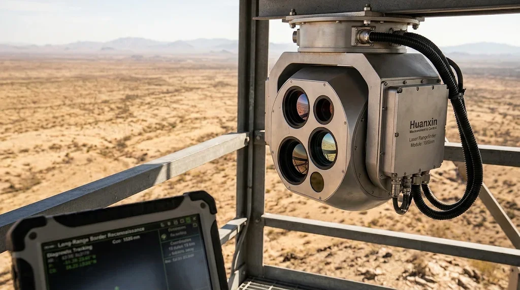
The Remote Frontier Challenge: Long-Distance Detection
Border perimeters rarely run through clean, accessible terrain. They cross wind-scoured mountain passes, featureless mud flats, and baked desert valleys where physical patrols cannot respond on short notice. If an electro-optical station only detects threats out to five or six kilometers, your command center has mere minutes to assess intent, mobilize ground units, or redirect aerial assets.
Pushing active detection and ranging past 12km—and out to 20km—fundamentally changes that operational tempo. It provides defensive teams with the tactical depth needed to coordinate responses well before unauthorized vehicles or personnel reach a physical crossing point.
Atmospheric Interference: Managing Scintillation and Path Loss
Photons traveling through 15,000 meters of open air face severe degradation. Suspended aerosols, humidity pockets, dust, and temperature differentials scatter and attenuate optical energy.
Aerosol Scattering: Microscopic water droplets and dust disperse both outgoing emitter pulses and faint target reflections.
Thermal Scintillation: Heat rising off sun-baked soil creates turbulent refractive pockets. This "mirage" bends optical paths, jittering target images and diluting laser power density over distance.
Beam Divergence: Without high-grade collimating optics, a tightly focused laser pulse expands into a wide cone downrange, dropping the energy per square meter below the threshold required for a reliable return.
Core Emitter Physics: Why 1535nm Erbium Glass Dominates
Decades ago, defense systems relied heavily on 1064nm Nd:YAG lasers. While powerful, Nd:YAG systems create major hazards along civilian borders, draw heavy power, and produce excess internal heat.
Today, a 1535nm erbium glass laser for border security represents the field standard. Operating within the short-wave infrared band, it delivers clear advantages over older architectures:
Because 1535nm sits outside the detection spectrum of common night-vision equipment, operators can ping suspicious vehicles repeatedly without alerting the occupants.
The Benchmark: Ranging a NATO Standard Target at 15km
Marketing claims often cite maximum ranges against massive, perfectly reflective surfaces like flat concrete walls. In real operational settings, targets do not cooperate.
The industry benchmark for proving a long-distance payload is successfully pinging a NATO standard target 2.3x2.3m ranging 15km. This metric simulates the front profile of an armored personnel carrier, scout vehicle, or supply truck.
Military vehicles often feature low-reflectivity matte coatings, irregular geometries, and dust layers that absorb or scatter incident light. An effective 20km laser rangefinder module relies on:
High-Purity InGaAs Avalanche Photodiodes (APDs): Delivering the quantum efficiency needed to detect weak return signals consisting of only a few dozen photons.
Narrow Optical Bandpass Filters: Stripping out ambient sunlight glare so the receiver focuses strictly on the 1535nm pulse.
Time-Gated Signal Processing: Ignoring false returns caused by roadside dust or birds close to the sensor.
Precision Gimbal Integration and Target Acquisition
Placing an EO station targeting laser inside a moving, multi-sensor turret demands rigid mechanical alignment. At 18km, a factory boresight error of just one milliradian translates to an 18-meter positioning miss—meaning your laser hits the dirt beside the target rather than the vehicle itself.
Eliminating Line-of-Sight Drift
Turrets mounted on desert towers face extreme day-to-night temperature swings. If the optical bench is made from poorly matched metals, thermal expansion will misalign the laser axis from the thermal and visible cameras. Modern stations solve this using:
Thermally balanced mounting plates (such as titanium or stress-relieved aircraft aluminum).
Active electronic boresight compensation within the system firmware.
Gyro-stabilized brushless motor drives capable of holding sub-milliradian stability in heavy gusting winds.
Transforming Raw Range into Tactical Coordinates
A distance reading by itself does not resolve an operational problem. To direct an intercept or pass targeting data to field teams, the payload functions as a complete long range target coordinate acquisition module.
When the operator lases a target, the mission computer instantly calculates the target's latitude, longitude, and elevation by combining the laser range, gimbal azimuth/elevation angles, and local GPS position. These coordinates stream directly into common defense mapping networks in less than a second.
Selecting Payloads: Standard vs. Custom Requirements
Different border installations face distinct structural demands. Mast-mounted sites prioritize maximum optical aperture and long-range clarity, while mobile patrol vehicles and airborne drones must work within strict size, weight, and power (SWaP) budgets.
For system developers balancing these mechanical trade-offs, standard catalog parts often fail to fit cleanly inside specialized turret housings. Huanxin Measurement & Control Technology Co., Ltd. operates as a dedicated manufacturer of Laser Rangefinder Module hardware, offering tailored engineering adaptations. From reconfiguring optical center heights and beam divergence angles to adapting communication protocols, Huanxin provides custom-engineered payloads designed to meet specific mission envelopes.
Environmental Hardening for Frontier Stations
A remote station cannot be babied. It must function continuously through blinding dust storms, sub-zero winters, driving rain, and corrosive coastal salt fog.
Key survival specifications include:
Hermetic Nitrogen Purging: Eliminating internal humidity to prevent lenses from fogging during sudden temperature drops.
IP67-Rated Enclosures: Ensuring fine silica dust cannot penetrate the optical chamber or gum up moving focus rings.
Diamond-Like Carbon (DLC) Window Coatings: Protecting front-facing lenses from pitting caused by windblown sand particles, preserving optical clarity over years of field exposure.
Integrating field-hardened optronics with a precise 12km–20km laser core delivers complete perimeter visibility. By stripping away the cover of night, distance, and adverse weather, modern targeting stations give border protection forces the clarity and response time needed to secure vital frontiers.
Frequently Asked Questions
What makes 1535nm lasers preferable to 1064nm models for border security?
The 1535nm band is eye-safe because its energy is absorbed by the eye's cornea and lens before reaching the sensitive retina. Additionally, unlike 1064nm, 1535nm cannot be detected by standard image-intensifier night-vision goggles used by intruders, ensuring covert operation.
How does air turbulence affect laser ranging beyond 12km?
Ground-level heat creates turbulent pockets of varying air density, known as scintillation. This bends light rays, causing the beam to wander, diverge faster, and lose energy density. Advanced rangefinders overcome this through tight beam collimation and sensitive APD receivers backed by digital filtering.
What is the practical value of testing against a NATO standard 2.3x2.3m target?
A NATO standard target represents the realistic physical profile of a frontline tactical vehicle with low-reflectivity matte paint (typically 10% to 30% reflectivity). Hitting range benchmarks against this target proves the system will perform reliably against real vehicles rather than just high-contrast test boards.
Can custom rangefinder modules be retrofitted into existing surveillance gimbals?
Yes. Huanxin Measurement & Control specializes in tailored optical and physical footprints, adapting mounting points, connector types, and communication protocols to fit inside pre-existing or compact payload enclosures.
How does an EO/IR targeting station calculate exact GPS coordinates from a laser pulse?
The station's processor takes the high-precision distance measurement from the laser and combines it with the turret’s elevation and azimuth angles, along with the station's internal GPS and digital compass data. Trigonometric software converts these inputs into instant military grid coordinates.